

Tech Blog: Important drivers of southeast African Monsoon variability: is early Monsoon Onset prediction and planning possible?
FOCUS-Africa (FA) is an EU funded project which develops tailored climate services in the Southern African Development Community (SADC) region through the work of project partners and strategic partnerships between European and SADC organisations. FA builds upon past and ongoing related projects and advances the way climate services are developed and used throughout the supply chain of end-users. WEMC is a contributing partner across the various case studies and work packages, and the following work has been recently completed within case study 4 to act as a warning bulletin for the upcoming southeast African Monsoon onset and as a framework for future predictions.
Monsoon rainfall plays a crucial part in Africa’s socio-economic structure. Its year-to-year variability has profound implications for agricultural, energy, and other societal sectors. Identification of any large-scale climate drivers – those that regulate year-to-year fluctuation of monsoon seasonal rainfall in any region of Africa – would definitely have enormous implications for the livelihood of millions of Africans.
Two possible large-scale drivers are identified in this regard, which are El Niño Southern Oscillation (ENSO) and Indian Ocean Dipole (IOD). The ENSO is a periodic warming and cooling in the tropical Pacific and is usually measured by central to eastern tropical Pacific sea surface temperature fluctuations. On the other hand, IOD is a periodic, see-saw kind of variation in the eastern and western sides of the Indian Ocean Sea Surface Temperature. It is observed that ENSO and IOD, which may not be independent of each other, both have a very strong role in modulating the southern east African Monsoon rain in the October-November-December (OND) season. It is the season when total accumulated monsoon rain and the date of onset affect large parts of southeast Africa’s socio-economic activities. The relative positioning of the so-called Intertropical convergence zone (ITCZ), which passes through this location of southeast Africa in boreal winter, has an important role in the modulation of rainfall. The ITCZ usually separates the northern hemisphere from the southern hemisphere in terms of rain longitudinal bands and its shift in relative positioning between summer and winter plays an important part in seasonal monsoon rain in many parts of the world.

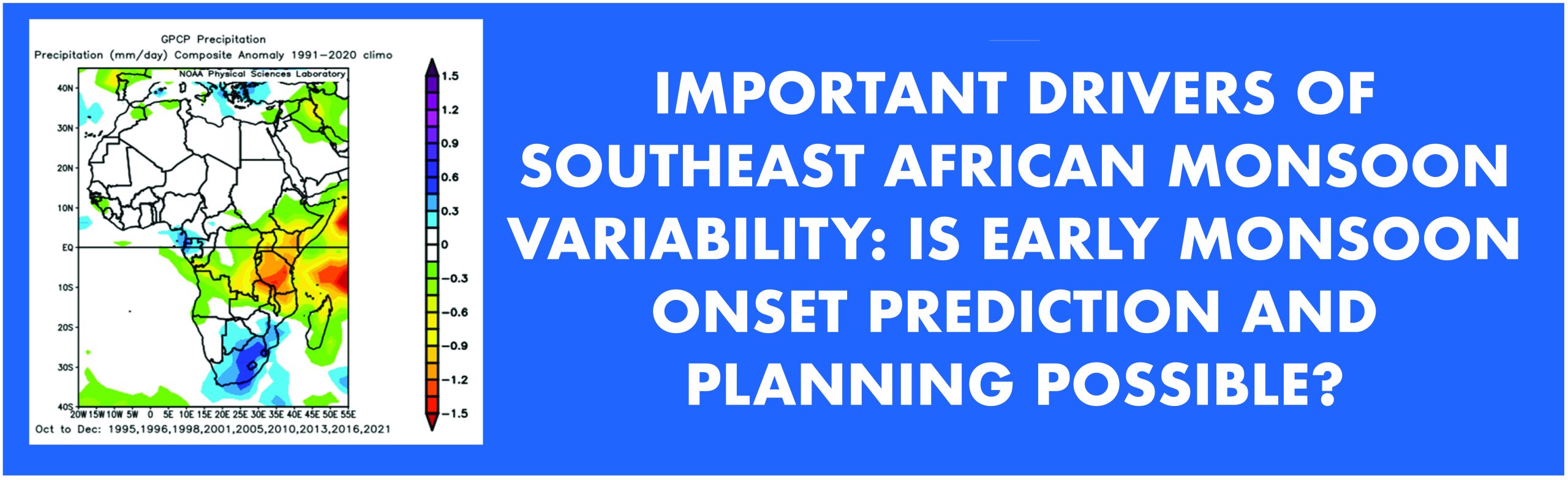
Figure 1. Precipitation changes (mm/day) for October to December in years when IOD and ENSO are both negative in July-August-September (JAS). Those years are mentioned at the bottom. In the whole season, a deficit of rain more than 100 mm from normal is noticed in regions of the southeast African sector. Results are similar using other data sources too.
ENSO and IOD both independently indicate very strong connections with monsoon OND rain around southern east Africa. A significant correlation is present even with a lead time of a season ahead as ENSO and IOD both usually change phase around June-July. To eliminate effects of confounding factors of ENSO and IOD when those are in the opposite phase, years having opposite signed ENSO and IOD phases are removed from the sample. This also help us explain what is occurring in the current rainy OND season, since both ENSO and IOD are negative. Indeed, a decrease in rainfall in the regions of southeast African sector covering Tanzania, Malawi and Kenya is noticed in OND (Fig. 1), when IOD and ENSO are both negative even in July-August-September (JAS). Amongst the affected African countries are: Tanzania, Malawi, Kenya; northern parts of Zimbabwe, Mozambique and Angola; southern part of Democratic Republic of the Congo, Ethiopia and Somalia (Fig. 1).
In the last thirty years, a total of nine years matched the criteria and all of these nine years showed a deficit in rainfall. In JAS 2022, ENSO and IOD were both in a negative phase, and for the second consecutive year, therefore exacerbating the effect of the reduction in rainfall. Conversely, when both ENSO and IOD are positive in JAS, excess rains in OND for those regions of southeast Africa are usually noted.
Following past records, it is again expected that this 2022 OND rainy season is likely going to have a large deficit in rainfall in a large part of southeast Africa. Currently, IOD and ENSO are both strongly negative and unlikely to change phase in the 2022 OND season. In such circumstances, when IOD and ENSO are both negative in the JAS and OND seasons, significant reduction in the OND monsoon rainfall is expected, based on past records. As of now, observations during the start of the OND rainy season are conforming this rainfall deficit for most stations in southeast Africa.
For example, a location like Kibaha (38.96 ˚E, 6.83 ˚S) in Tanzania, for which we have abundant data, a total of around 216 mm cumulative rain is expected from 1st July until the end of the year (with one standard deviation of 44mm), which is only 56% of the long-term mean (Fig 2 a and b). However, Fig. 1 indicates the estimation of rain deficit from normal years will be very similar for other surrounding locations of southeast Africa too. Rain in JAS is minimal for all those African countries and major precipitation starts from October onwards. Interestingly, when IOD and ENSO are both positive in JAS and OND, the amount of that total rain is more than doubled (546mm) with a standard deviation of 210 mm. On average, namely considering all years together, the amount of cumulative rain in Kibaha is 381 mm with standard deviation 169 mm (Fig 2 a and b).
Can such predictions be used for future planning in optimizing agricultural and energy outputs, therefore mitigating severe consequences and losses? Can we also take advantage of favourable weather scenarios when excess monsoon rains are likely to occur? What additional planning and mitigation strategy can be adopted for the 2022 OND season?
To mitigate untoward challenges due to the shortage of rain, some advance planning may be made based on such climate warnings. Enhancing natural water storage, storing rain via dams, and rainwater harvest could be possible useful actions. Deep water wells can be used to save water for later use for irrigation purposes, by also managing its use for electricity generation. Restoring and renovating old wells as well as digging new deep water wells could be planned beforehand. For mass use of deep-water wells (if run by electricity), electric generation powers need to be prepared well in advance, to provide for high water demand. Less water sensitive varieties of crops should also be considered.

Figure 2. Cumulative rain (mm) and Onset of Monsoon (OND) in Kibaha, Tanzania using Climate Hazards Group InfraRed Precipitation with Station (CHIRPS) data for 1993 to 2021 based on various ENSO and IOD phases. Top for Cumulative rain: a) average from 1st July to end of December with uncertainly range marked; b) boxplot showing variations of cumulative rainfall and median values. Bottom for Onset days in two different techniques in a form of boxplot: c) based on an Alternate Technique that focuses on cumulative rainfall; d) based on the current technique used by the Tanzanian Meteorological Authority (TMA). In 2022, we are in Case 1 situation. Results in the plot made use of CHIRPS data, as this dataset is the most consistent with station observations than others we tested; by using the CHIRPS dataset it is therefore possible to compute accurate Onset estimations for many other places (or average over an area).
False alarms for the onset of the rainy season, associated with a long dry spell after an initial spur of precipitation, which has major implications for agricultural crop failures, need to be accounted for too. A technique (Fig. 3) that considers cumulative amounts of seasonal rainfall (see Macleod et al. 2018; Zampieri et al. 2022) can overcome this issue. Considering soil moisture holding capacity, the amount of cumulative rainfall necessary for sowing seed and successful planting is likely to vary regionally. Other climate factors, e.g, evapotranspiration etc., which are necessary for crop production are often linked with temperature too – though after rainy days, usually temperature drops down. Hence cumulative amounts of precipitation in a rainy season play a paramount role and cater to the most useful indicator for agricultural needs.

Figure 3. A technique using cumulative rainfall identified the Onset and Cessation of monsoon (OND) in a location Kibaha, in Tanzania in 2017 using CHIRPS data. In this method, a change in cumulative rainfall from the annual average (Y axis, right), shown in blue, is plotted over time (days since 1st July in X axis). The time of long-term daily change in phase from decrease to increase is defined as the Onset date, while the reverse behaviour is the Cessation date. Onset in this method for 2017 (OND) is identified as 23rd Oct, cessation on 9th Dec and duration of the seasonal monsoon 47 days. It was a normal rainy season in 2017 and the day of Onset in this method very closely matched with the official government method.
Considering the Kibaha location, the average Onset day, based on 30 year average, identified by this technique is 16th November (day 321 starting from 1st January, with a standard deviation of 26 days); while with the method used by the Tanzanian Meteorological Authority (TMA) it is 31st October (day 305, standard deviation of 23 days), Fig 2 c and d. Unlike the method presented in Figure 3, the method used by TMA accounts for the number of four days since the start of rain above a threshold of total 20 mm, with at least two wet days (more than 1 mm rain a day) and no dry spell in 10 days or more within next 30 days.
With both methods yield a late Onset for rainfall deficit years, and instead an early Onset in years of excess rainfall. In years when IOD and ENSO are both negative in JAS, and this continues till OND season, the average Onset day based on the cumulative rainfall’s approach is around 19th December (day 354, with a standard deviation of 9 days). Thus, considering these different factors, our analysis indicates a very late onset in 2022. Onset days (OND) based on the TMA’s technique also suggest late onset in 2022 but considerably earlier than that indicated by the cumulative rainfall method, namely around 9th November (day of the year 314, with a standard deviation of 25 days). Thus, in situations when both IOD and ENSO are negative, a large deviation in Onset day is observed between the two methods (Fig 2 c and d).
Using the technique based on cumulative rainfall, when IOD and ENSO are both positive in JAS and OND, Onset is identified much earlier, which is around 21st October (day 295), with a standard deviation of only 9 days (Fig. 2 c and d). The date is also similar based on the standard technique though with a higher standard deviation (25 days).
It is important to note that while the onset date is indicated here as a precise day of the year, given these estimates are based on past records, and not on precise forecasts (which themselves are anyway not possible with current technology), they should be considered as approximate values. Typically, when communicating Onset dates, a range of a week or even ten days is common. Thus, for the example of the Kibaha location provided here, the expected Onset for OND 2022 would be 15-24 December 2022.
Attention needs to be placed on Onset day as identified by the current standard technique in rainfall deficit years. The announced official Onset date (expected between 30th October to 22nd November 2022) is likely to be associated with a long dry spell or nominal rain afterward, which can be responsible for agricultural crop failures unless enough measures, such as those indicated earlier, are taken to account for these likely dry spells.
Acknowledgement: This work is part of the EU FOCUS-Africa project (https://focus-africaproject.eu/) and contributed by World Energy and Meteorological Council (WEMC).


