Want to be informed about air pollution data during COVID-19 restrictions?
Prepared by Prof. Alberto Troccoli.
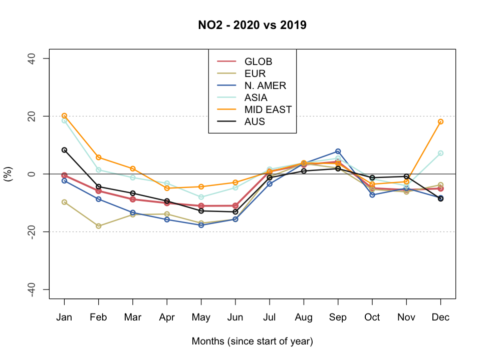
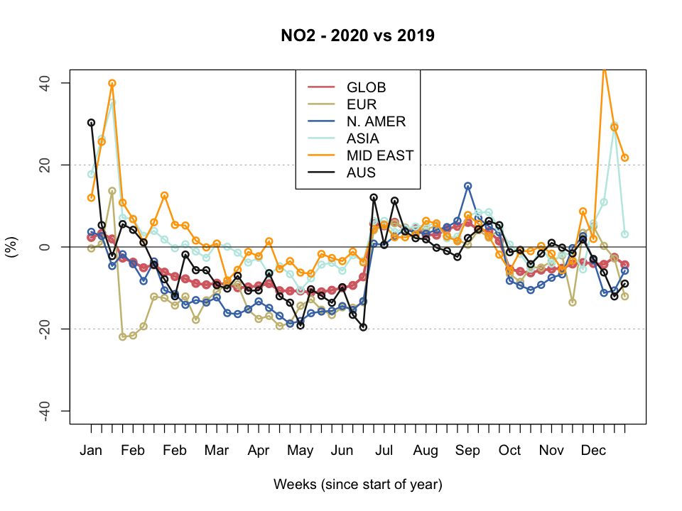
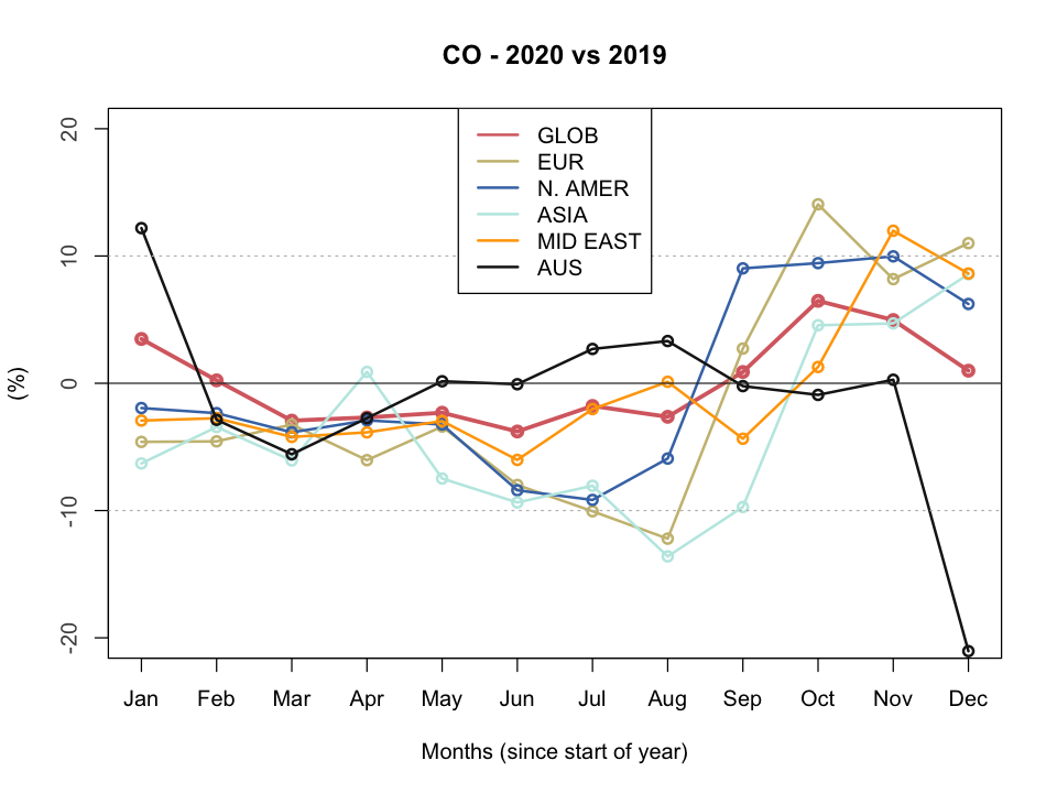
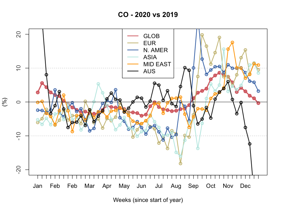
Two major air chemical components, which are also atmospheric pollutants, are shown here as a way to detect the changes in air pollution during the period of COVID-19 restrictions. Weekly values from the start of the year for Nitrogen Dioxide (NO2) and Carbon Monoxide (CO), both of them as total column, are displayed for the first weeks of the year (from 1st January).
As we discussed in our previous blog post, acknowledging the tragic impact of the COVID-19 outbreak on lives and livelihoods, this unprecedented situation presents us with an interesting opportunity to uncover what happens to the air quality around us and worldwide. The data presented here are taken from the Copernicus Atmosphere Monitoring Service (CAMS). Specifically, data come from the CAMS Near Real Time (NRT) Re-analysis which is available a few days behind real time. Re-analyses are combinations of observations (from ground stations, satellite, etc.) and a very advanced physical model. The CAMS NRT Re-analysis is downloaded at ca. 50 km x 50 km horizontal spatial resolution and every six hours (namely four values daily, at 00:00 UTC, 06:00 UTC, 12:00 UTC and 18:00 UTC).
Given the dependency of these variables of external conditions such as type of weather, economic productivity, traffic, etc. a week average is about the shortest time recommended when comparing these type of data across years, though monthly averages would perhaps be more appropriate. As we know, the restrictions due to the coronavirus have have been occurring at different times in various parts of the globe so weekly averages help us better relate these changes with the times the restrictions have been enforced. For a proper comparison, we would also need to assess external factors, so the data below need to be interpreted with a grain of salt. Also, due to the nature of these data there can be discrepancies between the CAMS NRT Re-analysis and the maps which often appear on the web and derived from Sentinel-5P/TROPOMI. Importantly, some, though not all, of these estimates are flawed as discussed in this blog from CAMS.
The movies show the weeks of the year (available to date, i.e. currently week 26) grouped into four, with the following pattern: full field for 2019 (top left), full field for 2019 (top left), difference between 2020 and 2019 (positive means higher values in 2020 compared to 2019, and vice-versa, bottom left), and difference between 2020 and 2019 as a percentage (bottom right). Five views are shown for each variable: Global, Europe, (a large part of) Asia, North America and Middle East. The number in square bracket on the titles is the weighted average for the region. These images will be regularly updated as more recent data become available. Monthly averages are avaialble on request.
For further information, please contact Prof. Alberto Troccoli (alberto.troccoli -at- wemcouncil.org)
Data courtesy of Copernicus Atmosphere Monitoring Service (CAMS)
Nitrogen Dioxide (NO2, in 10 -7 kg m-2)
 |
 |
Carbon Monoxide (CO, in 10 -4 kg m-2)
 |
 |