

WEMC Member Blog: Global Wind Atlas wind resource maps now available for every country
The World Energy & Meteorology Council (WEMC) has members across the globe, from a variety of backgrounds and expertise, doing work on a range of important issues to strengthen energy and meteorology education, research and collaboration. We welcome posts from our members communicating the fantastic work that they do. We are delighted to share with you this post written by Oliver Knight, a WEMC member working at The World Bank as a Senior Energy Specialist. If you are interested in becoming a WEMC member (it’s free!), find out more by clicking here.
Published: 14th January 2019
Oliver Knight (Senior Energy Specialist at The World Bank & WEMC Member). Edited by Kit Rackley.
The Global Wind Atlas is the product of a partnership between DTU Wind Energy and the World Bank Group, with funding from ESMAP, and includes mesoscale wind resource data generated by Vortex.
DTU Wind Energy are close affiliates of WEMC and will play a significant part in the upcoming International Conference Energy & Meteorology (ICEM2019) in June, hosted by DTU Lyngby campus.
Hot on the heels of a major upgrade to the Global Wind Atlas released in July 2018, where a global resolution of 250m was unveiled, the following September saw the launch of another significant upgrade.
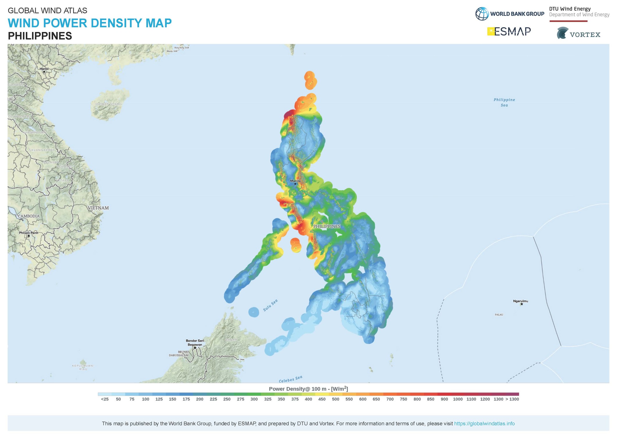
It is now possible for users to print high quality, A3-sized poster maps for every country in the world, in just three clicks! They can add a buffer of up to 30km to their map, allowing the inclusion of the offshore wind resource, as this map of the Philippines demonstrates.
There are plenty of other great new features, including:
- Improved workflow of saving, editing and exporting customized areas;
- Optimized responsive design for tablets;
- Addition of two zoom levels for wind power density, wind speed and roughness;
- Addition of zooming ‘below’ the wind layers (view the background map at higher zoom levels).
The team at Nazka Mapps has done a great job in developing all this in record time, and we look forward to your continued feedback. Version 2.3, which was released in November of last year saw further improvements, such as the ability to download GIS files for all wind layers per area of interest.
The Global Wind Atlas should also be appealing to a wider audience, along with its sister website, the Global Solar Atlas. Kit Rackley has been commissioned to write an educational article for a publication aimed at high-school teachers on the topic of climate services, in which both applications will feature. The continuous development of these applications and examples of their use by stakeholders from many sectors will certainly mean more news will follow in the future. Stay tuned!💡
Disclaimer: This post represents the views of the author and do not necessarily reflect the view of WEMC or any other agency, organization, employer or company.
WEMC Member Guest Blogs & Contributions:
- How hydrological cycles impact the worldwide energy industry (November 2019) – Vasilis Pappas, Senior Meteorologist, Trianel GmbH
- Should every company be considered an ‘energy company’? (October 2019) – Michael Ferrari, Managing Partner & Principal of Atlas Research Innovations
- The Climate Pocketbook: An example of educational outreach from experts (August 2019) – Sebastian Sterl, Researcher on Energy & Climate, Free University of Brussels (VUB)
- Malawi-UK Teacher Partnership Focuses on Clean, Affordable Energy (August 2019) – Noel Banda, Meteorologist & Climate specialist, Malawi Department of Climate Change and Meteorological Services
- Global Wind Atlas wind resource maps now available for every country (January 2019) – Oliver Knight, Senior Energy Specialist, The World Bank
- Prescient Weather’s World Climate Service launches “significant upgrade” (December 2018) – Jan Dutton, CEO, Prescient Weather

